
Fichier:Noord-Brabant position.svg

Taille de cet aperçu PNG pour ce fichier SVG : 200 × 236 pixels. Autres résolutions : 203 × 240 pixels | 407 × 480 pixels | 651 × 768 pixels | 868 × 1 024 pixels | 1 736 × 2 048 pixels.
Fichier d’origine (Fichier SVG, nominalement de 200 × 236 pixels, taille : 158 Kio)
| Ce fichier et sa description proviennent de Wikimedia Commons. | Accéder au fichier sur Commons |
Description
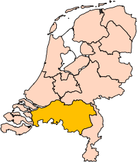
| Description | Location of the province of Noord-Brabant (North Brabant) in the Netherlands. |
| Date | |
| Source | Own work, based on freely available GIS data |
| Auteur | User:Mtcv |
| Autorisation (Réutilisation de ce fichier) |
Data: attribution required; my work: PD |
| Autres versions | I attempted to make an svg version of Image:Noord Brabant-Position.png (with less simplified boundaries) |
Clickable version

Conditions d’utilisation

|
Le détenteur des droits d’auteur de ce fichier, Centraal Bureau voor de Statistiek, autorise n’importe qui à l’utiliser pour n’importe quelle utilisation, pourvu que le détenteur des droits d’auteur soit correctement attribué. La redistribution, les œuvres dérivées, l’utilisation commerciale et toutes les autres utilisations sont autorisées. |
Attribution:
|
| Annotations | Cette image est annotée : Voir les annotations sur Wikimedia Commons |


Historique du fichier
Cliquer sur une date et heure pour voir le fichier tel qu'il était à ce moment-là.
| Date et heure | Vignette | Dimensions | Utilisateur | Commentaire | |
|---|---|---|---|---|---|
| actuel | 2 mars 2019 à 17:20 | | 200 × 236 (158 Kio) | Thayts | update |
| 3 octobre 2006 à 00:49 |  | 200 × 236 (158 Kio) | Mtcv | {{Information| |Description=Location of the province of Noord-Holland (North Holland) in the Netherlands. |Source=Own work, based on freely available GIS data |Date=2006-10-03 |Author=User:Mtcv |Permission=Data: attribution required; my work: PD |othe |
Utilisation du fichier
Les 3 pages suivantes utilisent ce fichier :
Usage global du fichier
Les autres wikis suivants utilisent ce fichier :
- Utilisation sur ar.wikipedia.org
- شمال بربنت
- آيندهوفن
- بريدا
- بارله ناساو
- تيلبورخ
- سيرتوخيمبوس
- قالب:بلديات شمال برابنت
- آلبورخ
- ألفن- كام
- أستن
- بيرخ آيك
- فيلدهوفن
- بيرخن أوب زووم
- بيرنهيزه
- بيست (هولندا)
- بلادل
- بوكل
- بوكسمير
- بوكستل
- كرانندونك
- كاوك
- دورنه
- دونجن
- دريميلين
- إيرسل
- إيتن- لور
- خيرتراودنبيرخ
- خيلدروب- ميرلو
- خيميرت- باكل
- خيلزه آن راين
- خورلا
- خرافه (هولندا)
- هارن (شمال برابنت)
- هالدربيرخه
- هيزه- لينده
- هيلموند
- هوسدن
- هيلفارينبيك
- لاربيك
- لانديرد
- لوب أوب زند
- مل آن سينت هوبرت
- موردايك
- نونن (خيرفن آن نيدرفيتن)
- أويرشخوت
- أويسترفايك
- أوسترهاوت
- أوس (هولندا)
- روسل- دي ميردن
- روسيندال
Voir davantage sur l’utilisation globale de ce fichier.