
Fichier:Rita 2005-09-23 1910Z.jpg

Fichier d’origine (5 600 × 7 200 pixels, taille du fichier : 6,88 Mio, type MIME : image/jpeg)
| Ce fichier et sa description proviennent de Wikimedia Commons. | Accéder au fichier sur Commons |
Description
| Description |
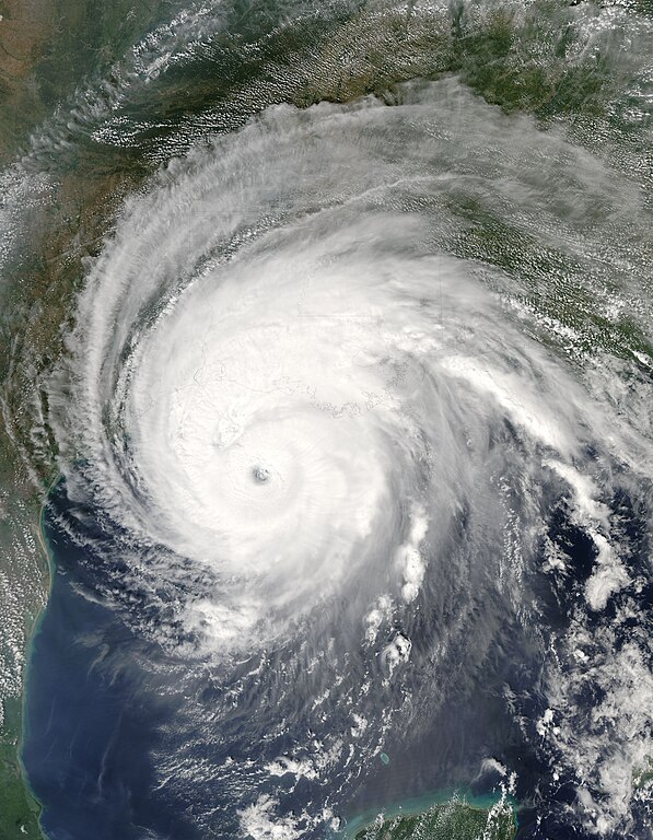
Hurricane Rita was slowly winding down as it approached the Louisiana and Texas shoreline on September 23, 2005. At 2:05 p.m. U.S. Central time, when the Moderate Resolution Imaging Spectroradiometer (MODIS) on NASA’s Aqua satellite captured this image, Rita was a dangerous Category 3 storm, down from the near-record-breaking Category 5 hurricane it was on September 21. At its core, Rita had sustained winds of 205 kilometers per hour (125 miles per hour) and stronger gusts. A mere two days earlier, the storm packed wind speeds of 275 kilometers per hour (170 miles per hour), making it the fourth most powerful storm ever measured. In this image, the outer bands of the storm already extend well over Texas, Louisiana, Mississippi, and Arkansas, affecting many regions devastated by Hurricane Katrina on August 29. Over the Gulf of Mexico, Rita’s well-defined eye has clouded over. This closed or “dirty” eye shape is typical of a storm that has reached its peak strength and is slackening. Though the center of the storm is forecast to come ashore in Texas near the Louisiana border, Rita will likely have a far-reaching effect. The massive storm has hurricane-strength winds that reach 140 kilometers (85 miles) from the eye, with weaker tropical-storm-strength winds that extend as far as 335 kilometers (205 miles) from the storm’s center. Rita will also bring heavy rain—up to 20 inches in some locations, the National Hurricane Center warns—high tides, and battering waves. For more images of Hurricane Rita, please visit the Natural Hazards section of the Earth Observatory. For more information about Rita, see the National Hurricane Center. |
|||||
| Date | ||||||
| Source | http://earthobservatory.nasa.gov/NaturalHazards/natural_hazards_v2.php3?img_id=13159 | |||||
| Auteur | NASA image courtesy Jeff Schmaltz, MODIS Land Rapid Response Team at NASA GSFC | |||||
| Autorisation (Réutilisation de ce fichier) |
|

Historique du fichier
Cliquer sur une date et heure pour voir le fichier tel qu'il était à ce moment-là.
| Date et heure | Vignette | Dimensions | Utilisateur | Commentaire | |
|---|---|---|---|---|---|
| actuel | 3 novembre 2006 à 03:31 | | 5 600 × 7 200 (6,88 Mio) | Good kitty | == Summary == {{Information |Description=Hurricane Rita was slowly winding down as it approached the Louisiana and Texas shoreline on September 23, 2005. At 2:05 p.m. U.S. Central time, when the Moderate Resolution Imaging Spectroradiometer (MODIS) on NAS |
Utilisation du fichier
Aucune page n’utilise ce fichier.
Usage global du fichier
Les autres wikis suivants utilisent ce fichier :
- Utilisation sur ru.wiktionary.org