
Fichier:CartesianPlane.svg

Taille de cet aperçu PNG pour ce fichier SVG : 600 × 600 pixels. Autres résolutions : 240 × 240 pixels | 480 × 480 pixels | 768 × 768 pixels | 1 024 × 1 024 pixels | 2 048 × 2 048 pixels | 625 × 625 pixels.
Fichier d’origine (Fichier SVG, nominalement de 625 × 625 pixels, taille : 84 Kio)
| Ce fichier et sa description proviennent de Wikimedia Commons. | Accéder au fichier sur Commons |
| Description |
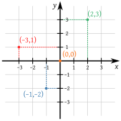
English: A small portion of the Cartesian coordinate system, showing the origin, axes, and the four quadrants, with illustrative points and grid. Part of a series in elementary mathematics.
Español: Una porción del plano cartesiano. Parte de una serie en matemáticas elementales. |
| Date | (UTC) |
| Source | |
| Auteur |
|
Cette image vectorielle non W3C-spécifiée a été créée avec Inkscape .
| Cette image a été retouchée, ce qui signifie qu'elle a été modifiée par ordinateur et est différente de l'image d'origine. Liste des modifications : small cosmetic changes to homogenize. L'image d'origine se trouve ici : Cartesian-coordinate-system.svg:
|
| Moi, propriétaire des droits d’auteur sur cette œuvre, la place dans le domaine public. Ceci s'applique dans le monde entier. Dans certains pays, ceci peut ne pas être possible ; dans ce cas : J’accorde à toute personne le droit d’utiliser cette œuvre dans n’importe quel but, sans aucune condition, sauf celles requises par la loi. |
Journal des téléversements d’origine
This image is a derivative work of the following images:
- File:Cartesian-coordinate-system.svg licensed with Cc-by-sa-3.0-migrated, GFDL, PD-user
- 2011-07-22T03:11:37Z Johnuniq 354x354 (53727 Bytes) remove left and down arrows on each axis per talk
- 2008-09-08T08:57:40Z Kbolino 354x354 (54425 Bytes) missed the y
- 2008-09-08T08:54:04Z Kbolino 354x354 (50985 Bytes) brute force: fonts to paths (the sans-serif text is DejaVu Sans, which is a PD modification to Bitstream Vera Sans, license at http://dejavu.sourceforge.net/wiki/index.php/License; the serif text is Gentium, under the SIL Ope
- 2008-09-08T08:45:23Z Kbolino 354x354 (27155 Bytes) fix fonts (hopefully)
- 2008-09-08T08:26:12Z Kbolino 354x354 (24182 Bytes) {{Information |Description=A small portion of the Cartesian coordinate system, showing the origin, axes, and the four quadrants, with illustrative points and grid. |Source=Made by K. Bolino ([[User:Kbolino|Kbolino]]), based u
- 2007-06-22T06:21:24Z Cronholm144 429x425 (21450 Bytes) tweaked image
- 2006-06-16T12:36:22Z Helix84 770x790 (8555 Bytes) {{Information| |Description= |Source= |Date= |Author=User [[:en:User:345Kai|345Kai]] on [http://en.wikipedia.org en.wikipedia] |Permission={{GFDL-user-w|en|wikipedia|345Kai}} |other_versions= Originally from [http://en.wikip
Téléversé avec derivativeFX
Historique du fichier
Cliquer sur une date et heure pour voir le fichier tel qu'il était à ce moment-là.
| Date et heure | Vignette | Dimensions | Utilisateur | Commentaire | |
|---|---|---|---|---|---|
| actuel | 9 août 2011 à 14:08 | | 625 × 625 (84 Kio) | Kismalac | {{Information |Description={{en|1=A small portion of the Cartesian coordinate system, showing the origin, axes, and the four quadrants, with illustrative points and grid.}} {{es|1=Una porción del plano cartesiano.}} |Source=*[[:File:Cartesian-coordinate- |
Utilisation du fichier
La page suivante utilise ce fichier :
Usage global du fichier
Les autres wikis suivants utilisent ce fichier :
- Utilisation sur es.wikipedia.org